help

Need help? Find answers to your questions, information about the Soar platform, and resources here on our Help page

If you came here looking for our Community Guidelines, please click this link.

FAQ

Use these section links to jump directly to your preferred FAQ

General FAQ

Why can't I upload a JPG image on the maps section?
Because of the way JPG images made, they don't have the correct information to correctly display on a map without going through a process called georectification.  We will be addressing this soon with our own Soar georectification tool.
How do I see up to date satellite imagery?
To view up to date imagery, you can checkout our free Sentinel and Landsat feeds or for high resolution feeds check out our SkyMap50 service.
Who provides the images on Soar?
The majority of images on Soar are crowdsourced by individuals who have created the maps and drone photos or uploaded out of copyright or public domain images.  An number of the maps and images are also provided by businesses showing their capabilities.
How do I download maps or images available on Soar?
At the moment, images cannot be downloaded directly from Soar (unless these are drone images specifically for sale). If you like a map or image, please visit the user's profile page to contact them.
Can I publish third party maps imagery on Soar?
Third party imagery can only be published if you own the copyright or have rights to publicly display the image.  Images under copyright cannot be displayed if you don't own the rights.  You can publish your own images or public domain and out of copyright images, however, we would recommend providing the source of the image when you do.

Satellite Imagery

How do I see up to date satellite imagery?
To view satellite imagery, navigate to ‘Satellite’ on the top right of the tab. You can check out our free Sentinel and Landsat feeds or for high resolution feeds check out our SkyMap50 service.
Can I get imagery of a specific date and time?
Unfortunately satellites available on Soar are constantly orbiting around Earth and only capture between 10am-12pm (depending on the satellite). We cannot guarantee the time any imagery is captured as it is dependent on the satellite’s orbit and the satellite’s revisit time. The best way to find out if there is imagery on the date you need, is to navigate to the ‘Satellite’ tab and choose your preferred satellite, draw an area of interest and see what imagery is available.
Can I get real time imagery?
No, unfortunately satellite imagery is not true real time. The satellites are imaging as it is moving in orbit and the data can take up to a day to transfer from the satellite to us. This is known as near real-time imagery. The most recent imagery available would be at most from the day before.
What times do satellites fly over where I am?
This depends on the satellite but generally imaging satellites pass over between 10am and 12pm local time each day as they orbit the Earth. Satellite orbits available on the Soar platform can be seen by selecting the satellite orbit button at the bottom right of the screen.
Can I get night time imagery?
Night time imagery is currently not available on Soar. We are currently working with some commercial satellite providers to onboard this type of imagery so stay tuned!
What's the difference between free and paid satellite imagery?
Unfortunately not at this time.  While a KML can be uploaded to the system to show on Soar, they cannot be used to place an order at this time. However, this functionality may become available in the future
Can I upload a shapefile to place an order for satellite imagery?
Unfortunately we don't support shapefiles at this time
Can I only draw a square or rectangle to order my imagery?
Yes. In future we may add the ability to order polygon sections but we are limited by what order requirements the satellite imager provider places on us.
Will you be getting more / different satellite feeds?
Yes.  We are currently in discussions with a number of other commercial providers to onboard their content onto Soar.  However, this is a complex process and takes time. Even free satellite services take time to onboard on to the platform.
What are the license conditions for using satellite imagery on your site?
Each satellite has its own license conditions for use of the imagery.
How much does SkyMap50 imagery cost?
SkyMap50 images are available as new collect and archival (historical) imagery. New collection imagery is priced at US$13/km² (minimum purchase is 50km²). Archival imagery is priced at US$9/km² (minimum purchase is 28km²).
What's different about SkyMap50?
What is novel about our 'click and collect' approach to satellite imagery is that unlike other providers the pricing is open, transparent and the pricing is pay as you go. We found that many suppliers have large lock-ins, large minimum orders, and complicated licensing conditions. Furthermore, the delivered scenes are often in 'bundles' meaning you need specialised software to collate, colour and mosaic. Via Soar your SkyMap50 imagery is delivered like Google Earth as a natural colour image. SkyMap50 can be your eye in the sky!
How quickly is the imagery delivered?
Archival imagery orders can take between 2 to 5 working days to process.
New collect imagery order can take anywhere from a few working days through to months, depending on cloud cover. For example, if your area of interest is in a tropical location, it maybe covered in cloud for many months of the year making taking images from satellites extremely difficult.
The stated delivery times are just a guide however and each will be different according to each order location and size.
What is the maximum cloud cover allowed in SkyMap50 imagery?
Archival imagery orders can choose whichever level of cloud cover you like. You can use the image previews as an indicator. However with new collect imagery, the maximum allowable cloud in your order is 15%. This includes shadows, haze and smoke - so you can be rest assured that 85% of your order will be cloud free. If your order has more than 15% cloud cover, we will re-fly the area for you for no extra charge until the 15% cut off is achieved.
Is there a super-fast express service for emergencies or rapid collection?
Yes! We have a very special product called 'SkyMap50EXP' which is a 100% guaranteed 24 hour turn around product which is available on any working day. This product can be used by news agencies, mining companies and security organisations that require super-fast turn around times. The price is US$50/km2 with a minimum purchase of 50km2. This is almost 10 times cheaper than the nearest competitive product in the marketplace. Beware however, that there is no cloud cover maximum with this product. If you choose to use this service, whatever cloud covers your area of interest at the time of capture, that is your final image. There are no refunds.
Can you provide real time satellite imagery?
Unfortunately, there is actually no 'real-time' satellite imagery available to non-military customers. There is however near real-time which is delayed between 24 and 72 hours depending on the orbitology. For example, if you were ordering a one off image, maximum scene size of 12 km x 12 km it would take about 48 to 72 hours. But if it was constant monitoring of a location, it can be imaged and delivered every 24 hrs into your Soar account. Many satellite companies offer daily coverage but this is a marketing gimmick as the actual turn around time to your access can vary up to a week. Moreover, you would have to pay a minimum collect fee of about $5,000. With SkyMap50 the pricing of $12km² is standard and capped.
Can I order an image for a specific date and time of day?
No. SkyMap50 constellation includes four satellites providing once daily global coverage. Images are usually captured between 10AM to noon local time every day.
Can I order a night-time collection?
SkyMap50 satellites are positioned so they are sun-synchronous. Meaning they only orbit areas that have the sun shining on them at any one time. You will not be able to obtain night time images.
Is it possible to be able to image a person?
Unfortunately this is not achievable using commercially available satellites. Humans are not distinguishable using even the highest resolution satellites available to the general public.
Can you provide historical satellite videos?
No. The SkyMap50 satellite is not a video capable satellite.
Can you provide an RPC or ground control points?
An RPC file can be provided with your SkyMap50 order on request. There is an additional service charge.
Can you provide imagery in multiple bands?
Yes, multiple bands can be provided with your SkyMap50 order on request. There is an additional service charge.
Can I search for satellite imagery by address?
To find your location, key in the exact address in the search bar of Soar (upper left of website). Wait a few seconds for the search to locate a list of possible matches then click on the correct result to show your location. Then click on the satellites tab and choose SkyMap50. From there you can either choose archival imagery to purchase or you can book an acquisition for the next satellite pass with a new collect.
How do I purchase SkyMap50 high resolution satellite imagery?
You can purchase SkyMap50 high resolution satellite imagery directly on Soar. Watch our YouTube tutorial videos on how to search for and order archival imagery and new collect imagery..

User & Account Information

Is it free to register?
Yes, registration is free - and quick. You can register here.
Why should I register for an account?
Having an account lets you comment on maps, use our visual collaboration tools, upload your maps, download imagery, and purchase high resolution imagery.
Can I change my first and last name after I register for a Soar account?
Yes, you can. Click on your profile name in the top right corner of the page and select ‘My Dashboard’. Once you’re in the dashboard, click ‘Edit My Profile’ - then you can edit your name and other details.
How do I change my profile picture?
Click on your profile name in the top right corner of the page and select ‘My Dashboard’. Once you’re in the dashboard, click ‘Edit My Profile’, then click on the camera icon next to ‘Update Avatar’. Hover the mouse over your current profile picture then click to update. You can then select your desired profile image from your device.

Once the new profile image is loaded, adjust the cropped area to your liking, click ‘Finish Cropping’ and click ‘Save Edit’.
Can I link my other social media accounts to my Soar profile?
Yes, you can add a link to your Twitter, Instagram, Facebook and LinkedIn profile, and even your website, on your Soar profile.

Click on your profile name in the top right corner of the page, then select ‘My Dashboard’. Once you’re in the dashboard, click ‘Edit My Profile’ and add your links to the ‘Social Media’ section of your profile.
How do I delete my account?
You can delete your account anytime by clicking on your profile name in the top right corner of the page then clicking ‘My Dashboard’. From there, click on the ‘Delete Account’ button near the top right of the screen.

It’s important to note that deleting your account is permanent and you won’t be able to retrieve your uploaded content after deleting your account.

Commonly Used Phrases

What is an AOI?
AOI stands for Area of Interest. This usually refers to an area on Earth (e.g. a town or a region) that you want imagery or maps from. Selecting an AOI means selecting the area of the Earth you’d like an image of.
What is pixel resolution?
A satellite image is made up of many thousands of pixels. Each pixel is usually represented as at ground level distance. For example, a satellite with a pixel resolution of 50cm means each pixel in the image from that satellite is representing 50cm x 50cm of what is on the ground. The smaller the unit of measurement in the pixel resolution, the more detail on the ground you are able to see in the image.

Resolutions compared: 50 centimeters vs 10 meters vs 30 meters.

What is a basemap?
A basemap is a map layer that is used as a background.

Navigating the Platform

Who provides the images on Soar?
All the content in the ‘Maps’ and ‘Drones’ tab are uploaded by our users. Content in the ‘Satellite’ tab is directly from the satellite imagery services.
How do I download maps on Soar?
Maps on Soar are not available for download. If you want to download them, we recommend you to reach out to the person who uploaded the image for permission.
How do I download drone images on Soar?
Images from the ‘Drone’ tab can be downloaded or purchased depending on the image.
How do I download satellite imagery on Soar?
Navigate to the ‘Satellite’ tab on the top right hand of the page to go to the Satellite page. Once there, you can select which imagery provider, draw an AOI and select your desired image. Images from Sentinel and Landsat are free and can be downloaded immediately. Images from our commercial imagery providers can be downloaded after purchase and delivery to your Soar account.

Uploading Maps to Soar

What file types are accepted to upload as a map on Soar?
We accept maps in GeoTIFF (.tif or .tiff) and in Enhanced Compression Wavelet (.ecw) file types.
Can I upload a JPG image of a map?
No, as they are not in the correct format to hold geographic information that allows the image to be placed on the map.
I’ve downloaded a satellite image from Sentinel/Landsat. Can I upload that as a map to Soar?
Yes, you can. All imagery from Sentinel and Landsat are under the Creative Commons license and you can freely publish and upload the imagery to Soar.
I’ve purchased a satellite image from Soar, can I upload that as a map to Soar?
Yes, you can. Once you have purchased a satellite image, the rights of the image belong to you.
Can I publish third party maps imagery on Soar?
Third party imagery can only be published if you own the copyright or have rights to publicly display the image. Images under copyright cannot be displayed if you don't own the rights. You can publish your own images or public domain and out of copyright images, however, we would recommend providing the source of the image when you do.

Uploading Drone Images

What file types are accepted to upload as a drone image on Soar?
We accept drone images in Portable Graphics Format (.png) or Joint Photographic Experts Group (.jpeg) file types.
Do I need to set a price for my drone image?
No, you don't need to set a price. If you would like your images to be freely available, then just set your image to be ‘FREE’. Once I’ve set the price for my drone image after upload, am I able to change it later?

No, unfortunately once you have decided on a price, you are unable to change the price of the image from your user dashboard. If you do want to change the price of your image, then you would need to delete the image from your account and reupload it to set a new price.

Drones

Can i download drone images from Soar?
Some drone images are free to download whereas some other drone images are paid. Free images are able to be downloaded immediately. Images that have a price can be downloaded after completing payment.
Why do some drone images not match up to the map?
Due to the limitations of the drone photo format, they have only one coordinate on the earth. To properly display, a map needs at least 4.

Content guidelines and standards

All content must be uploaded with an appropriate description and tags
Descriptions and tags are important for making your image discoverable and helps other users better understand what they are seeing. If your map or image lacks a proper description or tags it may be rejected.
All content must be clear, readable, and medium to high quality
Maps and images which are too blurry, have poor colouring or are generally unclear and unreadable may be rejected. An image can be graded as poor quality from a variety of factors including: low resolution, compression, white-balance, blurriness, obstacles, and so forth.
Maps must be rectified correctly and placed in the right location
We’re all about accuracy and if you’re uploading a map, it must line up correctly on the Earth. If your content does not contain Exif geolocation data and/or is not manually placed correctly on the world it may be rejected.

A key feature of Soar is using the transparency slider to compare imagery. If the content doesn’t line up with the base layer, it becomes difficult for users to compare imagery. Some slight misalignment or warping is acceptable, but anything that greatly affects the comparative properties of the map may not be approved.
Map content should add value for other users and fit the definition of a ‘map image’
Soar is a collaborative platform, and our hope is that all of our content will provide value for our users. For that reason, we can’t accept blank maps or line art cartoon maps that don’t have enough data on them (such as context, labels, or a legend) to be considered a true ‘map’. Especially when they have exaggerated or warped a location that’s incomparable with the base layer.

We’re not saying you can’t be creative - artistic maps can be useful and definitely have a place on Soar - as long as they are true maps which are geographically accurate and in context.
Content must be the correct top down angle of view
Soar only accepts top down images to allow for a better mapping experience. If you upload a map or an image captured by a drone that is on an oblique angle, it will be rejected.
Offensive content will not be tolerated
We have a zero tolerance policy to content which is inflammatory, offensive or in poor taste. We do accept some maps which depict sensitive topics, as long as they’re done in an informational/educational and tasteful way.
Copyright and intellectual property rules

We are unable to publish you map unless you have a right to publish the map or image publicly through:

  • Owning the copyright to the map or image uploaded
  • Having a license to publish
  • The copyright has expired
  • It is published under Creative Commons license.
  • In all cases if you have acquired from a third party source with expired copyright or Creative Commons license, please credit the map creator or source in your description.
Examples of content which would not be accepted:

Line art maps that only contain lines with no context

Line art maps that only contain lines with no context

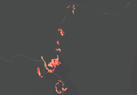
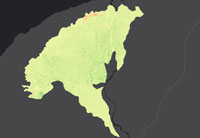
Blank maps that add no value to the platform (no context, no labels, no legend)
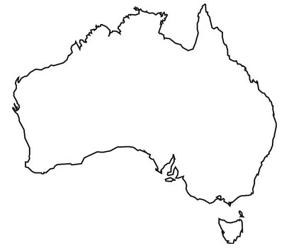
TUTORIAL VIDEOS

Learn how to register an account with Soar

Learn how to use the Explore tab on Soar

Learn how to view, download and share satellite imagery on Soar

Learn how to upload maps and satellite imagery on Soar

Learn how to order new collect SkyMap50 imagery on Soar

Learn how to find drone imagery on Soar

Learn how to order SkyMap50 Archival Imagery on Soar

Learn how to upload drone imagery on Soar

Learn how to comment, annotate and collaborate using maps & imagery on Soar

View our full tutorial page

Support documents

Upload Guide - English version

Document outlining the platform upload procedure in English.

Upload Guide - Chinese version

Document outlining the platform upload procedure in Mandarin.

still need help?

Want help using the platform?

Book a free demo session with one of our experts. A Soar.Earth demo runs for about 15 minutes. You'll be walked through the platform step by step, with time set aside to answer any questions you have. Book a session with us by selecting one of our highly trained specialists below.

If you're running late to a booking, please contact your specialist as soon as possible. We're happy to help if you give us a heads up, but a demo booking will be forfeited if you are more than 10 minutes late with no prior contact or explanation.

book a demo with diana

Diana can show you how to get the most out of Soar.Earth and how it can be used to share your maps and imagery.
She holds a degree in Conservation Biology and Geographic Information Systems. Her areas of interest are environmental management and conservation.

View Diana's full profile here.

Schedule a demo with Diana

If you didn't find the answer to your question, please email us.