Every day, we need to collect huge volumes of information about our planet. Scientists, businesses and humanitarian efforts all rely on this information in their work. Yet, it can be difficult, expensive and sometimes even impossible to gather all this data by hand. That's where remote sensing can help.
Our eyes in the sky
Remote sensing is the act of observing objects from a distance. This means you can understand features on Earth without being in physical contact with them.
So how can we observe an area we are nowhere near? Remote sensing uses sensors to capture information. Sensors are installed on drones, airplanes, space shuttles and, our personal favourite, satellites. These sensors observe the earth’s surface and send the information back to us in the form of imagery.
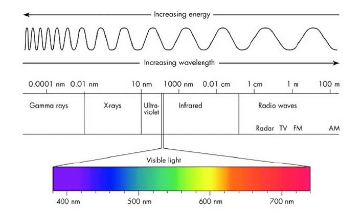
Sensors work by picking up electromagnetic radiation, a form of energy that comes from the sun. Electromagnetic radiation is made of a spectrum of wavelengths. This includes the visible light spectrum which is what we can see through our eyes.
Depending on the sensor type, they can pick up more than what is in the visible light spectrum, such as infrared and microwaves. This is known as the spectral resolution of the sensor. The higher spectral resolution a sensor has, the better the sensor is able to tell wavelengths apart from each other.
There are two forms of remote sensing, Passive and Active remote sensing. Passive remote sensing is a sensor that picks up energy from outside of the sensor, like the sun. Active remote sensing, is a sensor that releases and receives radiation, usually in the form of radio or laser pulses.
Since passive remote sensing sensors depend on outside energy, they can only capture images during the day. Earth observation satellites are the most well-known example of a passive remote sensor.
Photos from space
Earth observation satellites are launched from Earth into space and ‘placed’ into an orbit to observe the planet. They remain in orbit from Earth’s gravity, like how the Moon is in orbit around Earth. As the satellite moves along its orbit, it captures images of the ground below. Satellites like
Landsat 8 and
Sentinel 2, which you can view at
Soar, are constantly capturing images whilst they move along their orbit. On the other hand, SkyMap50 only captures an image of an area along its orbit when someone (like you) puts a request for it.
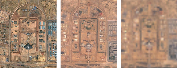
On Soar, users can access imagery from a range of satellites. You can download images from Landsat 8 and Sentinel 2 for free straight off the platform. Landsat 8 has a resolution of 30 meters and Sentinel 2 has a resolution of 10 meters. Soar also has access to Skymap50 imagery that has a 0.5-meter resolution, and it can be downloaded at a cost.
Spatial resolution is the dimension on the ground that is present in a pixel. The higher the spatial resolution, the more detail will be present in the image. In this case, SkyMap50 has the highest spatial resolution, followed by Sentinel 2 and then Landsat 8. A visual representation of differences in spatial resolution can be seen in the images below.
The rate of which a satellite moves along its orbit could vary from satellite to satellite too. This affects the amount of time it takes the satellite to revisit the same location. This is known as temporal resolution or the revisit time of the satellite. A satellite with a higher temporal resolution will take less time to revisit the same location. Sentinel 2 takes 5 days whereas Landsat 8 takes 16 days to revisit the same location. This means that Sentinel 2 has a higher temporal resolution than Landsat 8.
Why remote sensing mattersThe idea of remote sensing is to look at something on Earth remotely from a sensor like a satellite. Depending on the feature of interest, the source of the image (and its resolution) is something that needs to be considered.
For example, if you are differentiating between types of buildings, then choosing something with high spatial resolution would help identify buildings easily since there would be more detail in the imagery. If you are monitoring the movement of a wildfire, you would most likely want images frequently. Choosing a sensor with a shorter revisit time would be beneficial in this case so you could track the progression of the fire over time. If you are looking at identifying different types of vegetation, then a sensor that detects a wide spectrum of wavelengths might help tell apart different plants as the plants might reflect different wavelengths of light differently.
There is no single sensor that has all high temporal, spatial and spectral resolutions. That’s why it’s important to consider the type of project, then choose the appropriate sensor type based on that. Knowing what resolution to prioritise will help make the decision of choosing a sensor easier.
On
Soar, comparing between different satellites is easy. Gone are the days where you’d need to switch between tabs just to decide between imagery sources. You just have to decide on an area of interest and the available imagery for that area is loaded on demand.
The download process is also straightforward: with a single click of a button, an image of your area of interest is downloaded. It’s easy, intuitive and if you do get stuck, you can always refer to one of our
tutorials.