drone construction monitoring

An in-depth guide to drone construction pregress reporting

October 2, 2021

Rich Carpentier, a professional drone photographer, web designer and instructor explains what it takes to do drone construction reporting well.

Rich Carpentier is a website developer and professional photographer. After starting his own business, RLC Design Services, he created AZ Drone, an aerial data collection services company operating from Prescott, Arizona. To share his experiences from moving to the drone industry, Carpentier started his own YouTube channel, where he posts videos about topics such as digital photography and editing, building a drone business and autonomous drone flights. Apart from making YouTube videos for drone mapping, he is active as a teacher, having developed two Udemy photography courses

Carpentier had been streaming videos as early as 2006, long before there were professional YouTubers. His video streams were meant for family and friends, who followed his travel adventures while traveling the country in an Airstream mobile home through Colorado, Nevada, New Mexico and Arizona. These were broadcasted from a local internet spot he carried with him while out on the road. This also enabled him to work remotely before companies allowed their employees to do so.div block.

During the Soar Cast, Carpentier explains why 2005 proved to be a crucial year that led to the creation of his own business and the decision to pursue his interests, instead of keeping his job as a network engineer:

"Before I hit the road in 2006, I was getting interested in drones, apart from building websites and doing network engineering. In 2005, I got sick and the illness took about a year to diagnose. Being allergic, I decided I could better manage my environment from the mobile home while traveling and working remotely. So crafting my own business became a necessity at that point."
With regards to current drone photography projects, Carpentier tells that he’s been active doing drone construction progression reporting, flying client sites with a drone. This work also involves showing build-outs from start to finish, enabling clients to see projects through to the end. In reality, this means that Carpentier visits job sites when they’re vacant, which is during the weekends. Carpentier explains that this is done because his clients require clean, open area construction sites without construction workers present, while one the one hand current flight restrictions in the US prohibit flying over people with a drone unless a waiver has been issued. Most of his clients are remote, with most communication done by email and having Carpentier prepare status updates and real-time progress reports so they don’t have to leave where they are.
Before the data collection starts, Carpentier usually does some customer education as oftentimes his clients are not sure of what they want in terms of deliverables. Apart from asking upfront questions about their requirements, a demo flight is done of the actual construction location with some samples that show what is possible. These are put into a presentation website so that the client can view the results from the office. Oftentimes, clients are happy to find other deliverables that fit their needs in a better way than the ones they initially asked for.

Carpentier explains why he uses a presentation on a custom website to present a sample project to a potential client:
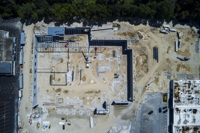
"Not everyone in the office knows what they’re looking at when I present them the data in the form of an orthomosaic or video time-lapse. By putting this into a presentation on a custom web page for them, it’s easier to view because not everyone you’re working with is an engineer or an architect; some of the people are office staff who don’t know what they’re looking at, but they’re going to be handing it off to their boss afterward, which is why we like to make it as easy as possible for them to see the results quickly. We also provide them all the data, so if they want to go deeper down the rabbit hole to do some 3D modeling. We can do it for them too, but they’re paying us primarily to collect the data for them."

Underestimating what it is to be a drone photographer

As the drone industry is progressing, Carpentier notices a great demand for knowledge. In his job as an instructor, Carpentier is often approached by other drone pilots who ask him how to present different deliverables nicely and easily. That’s why he decided to develop a new online Udemy class that takes them through the whole drone photography workflow starting from data collection, data processing/editing, to producing the final deliverable.

The lack of knowledge among drone pilots comes from underestimating the drone business as a whole, says Carpentier:
“I think what a lot of people fail to realize when you’re getting into the drone business is that it’s not just flying the drone: you also need to be a video editor, as well as a photo editor. On top of that, you also need to have some IT background and be a web designer. There are a lot of checkboxes to tick off if you want to do a full package for clients in the construction industry, so just grabbing the drone is not going to be enough.”
The Soar platform continues to serve the needs drone image hungry consumers who are utilising drone images in news and media, construction, land management, resources, and many other critical industries. If you have a special technology use case challenge, the team at Soar is keen to assist and provide a solution. We monitor our SM feeds closely and are always quick to respond and reach out to our users and clients.