September 6, 2023

The History
At over 4,000m above sea level, on the slopes of Puncak Jaya in the Sudirman Range in eastern Indonesia, you’ll find the fragile remains of Asia’s last tropical glaciers. They are a marvel of nature, situated in an equatorial region at only 4 degrees latitude south; a region typically characterised by lush tropical rainforests with a near-constant average temperature of 28°C at sea level. But the sheer altitude of the peak keeps the temperatures cold enough at the top to not only allow for snowfall to occur - but glaciers to exist and grow. At least, until now.
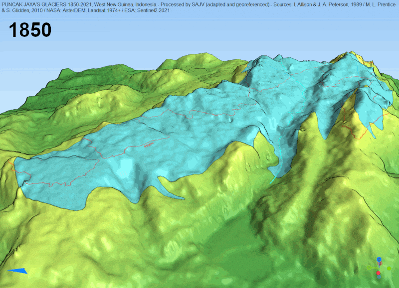
Prior to the industrial age in the 1800s, these mountain slopes were permanently covered in snow and ice, creating the glaciers. Regular snowfall maintained a stable equilibrium of gain and loss of snow across the highest peaks of Puncak Jaya seasonally. In the 1850s, the boundaries between the snow-covered and snow-free areas, called the snowlines, were registered and have been observed ever since, allowing earth scientists to have an incredible data log of one of the most unique glacial systems in the world.

Snowline extent of Indonesian glaciers between 1800 and 1850 which probably covered at their width over 4km in width. View the map on Soar
Since then, the observations have revealed an intense receding of these glaciers. Satellite imagery of the area over time shows basal melting (melting of the glaciers from the bottom), and, consequently, the snowlines shrinking. Some scientists predict the entire glacier could be completely gone within the next few years.
A beautiful hand drawn map of Puncak Jaya made in 1936 as part of the Carstensz expedition.
View the map on Soar.
Animated 3D model of snowlines from 1850 to 2021 using SRTM DEM base data.
Where did all the glaciers go?
Experts believe that rising air temperatures are the main culprit for the glacier rapidly melting away. In a tropical region such as Indonesia, the temperature at the mountain peaks is only just cold enough to maintain snow; so even a rise in temperature of just 1°C can decimate the glaciers. Other factors which may be impacting the region include the reduction of cloud cover over the mountains, a decrease in humidity levels, and interrupted rainfall patterns.

The first Landsat-1 full film image taken in 1974 showing the glaciers in the centre.
View the map on Soar.
Our team used various topographic maps and satellite imagery to estimate the snowlines at various time intervals between 1850 and 2021. You can see in the map below how the snowlines have receded over time.
A series of satellite images were also uploaded to Soar, supporting the hypothesis that the snowlines are retreating, as well as confirming the disappearance of previously snow-covered areas, which were not glaciers, but equally important due to the microclimate support they gave. The full list of maps with their links to Soar are below:
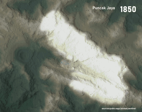
Animated sequence of snow area receding on Puncak Jaya’s glaciers using various data sources ranging from implied cartographic surveys, aerial imagery through to satellite imagery. Note the construction of the Grasberg copper mine in 1972 to the west of the image.
The situation at hand
The team used this imagery to calculate the glacial loss between dates and found the percentage of loss has been accelerating over time. Since 2015, after losing more than 99% of all its ice as registered in 1850, which then covered an area of about 9x3km, the Puncak Jaya Glacier remains now have been restricted to only four separated small ice patches of about 200x200m each. At this rate, it’s plausible that these glaciers will be effectively melted away within the next few years at best.
While it would be devastating to lose them, the question now is whether the damage done is irreversible. The accelerating rate of disappearance seen in maps and satellite images doesn’t bode well for these natural wonders.
If these glaciers do disappear, it would not only have an impact on the natural equilibrium of climatic patterns in the region, but also take away from the world one of the most unique tropical montane systems. By sharing this data and imagery far and wide, and attracting the attention of scientists and community members, we hope we can see a change for the better.

This blog was written by:
Sergio Volkmer
Sérgio is a mapping and remote sensing enthusiast, producing content for Soar. He studied geology and holds a Master of Philosophy, and is now an architect and contributor to OpenStreetMap and OpenData communities. He believes that information and knowledge are first steps towards personal fulfilment that lead to a better world.
View author's Soar profile